
Mapping The Future GIS Is Changing Health Care Delivery
Ric Skinner calls it “hospital-land security.”
Most everyone knows of the new national emphasis on homeland security in the wake of 9/11, but, according to Skinner, disastrous events have always been possible in any community, and private health organizations such as hospitals need to prepare for that contingency.
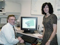
Thus is born one more use of Bay-state Medical Center’s award-winning Geographic Information Systems (GIS) effort, said Skinner, the senior GIS
coordinator in the hospital’s Health Geographics Program.
GIS is a computerized system that analyzes geographic, health, and demographic data and displays the results in maps, charts, and tables. And a program which Baystate has already used to track breast cancer rates and youth violence trends is now being applied to security and emergency-response strategies in a theoretical disaster.
“We’re looking to develop these things for Baystate, but we anticipate they will also become a model for hospitals in the region and across the state,” Skinner said.
Baystate’s successes using GIS technology led to its earning the Special Achievement in GIS Award at the Environmental Systems Research Insti-tute’s annual International GIS Users Conference in San Diego earlier this summer. The Springfield facility was one of 135 sites out of 100,000 worldwide — and the only hospital — to receive the award, reflecting how new GIS still is on the health care scene, said Dr. Richard Wait, chairman of Baystate’s Department of Surgery and director of the Health Geographics Program.
“Very few medical and academic institutions in the United States use geographic information for health care purposes,” Wait said. “GIS has wide-reaching benefits for Baystate, its health care professionals, the community, and other partners. It has set the groundwork for the future of health care delivery in Springfield.”
And, as The Healthcare News found, GIS is making a difference in how the business of healing is conducted in hospital-land.
Changing Roadmaps
In its current mode, GIS creates detailed maps of cities and regions and displays not only physical attributes of the area but also dozens of demographic qualities, from population and ethnic breakdowns to economic and marriage statistics.
First developed in the 1960s, GIS has been used by municipalities for many years in applications such as tracking property values and planning infrastructure improvements.
“It’s an analytic tool that enables us to explore the relationships between geography and data,” said Amy Pasini, GIS and Injury Prevention manager at Baystate. “When you consider that more than 80{06cf2b9696b159f874511d23dbc893eb1ac83014175ed30550cfff22781411e5} of health data has a geographic component, it only seems logical to take advantage of that with GIS.”
Still, health care applications of the technology were slow to be developed. Progress was stepped up in 1994, when President Clinton issued an executive order directing federal agencies to work with state and local governments and the private sector to develop the National Spatial Data Information Infrastructure to establish standards for GIS development.
The technology was first used by health organizations soon after, as agencies such as the Center for Disease Control and the National Cancer Institute supported the development of software to map diseases, identifying clusters of high incidence.
In fact, tracking cancer rates was one of Baystate’s original GIS applications, said Jane McCall, biostatistician and spatial epidemiologist for the Baystate program.
“Our purpose was to create a profile of communities in Springfield in need of increased breast cancer screening to aid in planning intervention programs,” McCall said. “Specifically, we wanted to locate geographic areas with high rates of late-stage breast cancer and identify contributing socioeconomic and demographic factors.” This information, she said, can be used to determine where best to place mobile mammogram units and how to design more demographically appropriate educational materials and public service messages.
The hospital is currently using 2000 census data in some of its GIS studies. However, that data will not be hopelessly outdated in five years, as the U.S. Census Bureau is following up with its American Community Survey — a smaller-scale gathering of information taken annually from cities and regions with populations over 65,000. Hampden County was one of 31 sites chosen to test out the survey before it was implemented nationwide, and McCall and Pasini were later summoned to Washington to explain some of its practical uses to congressmen.
Another early application of Baystate’s GIS program was in the area of youth violence, McCall said. Data maps displayed areas at high risk for violent incidents involving youths, and then the GIS team mapped the distribution of schools, vacant housing, median household income, and a variety of demographic and economic indicators.
By comparing that data to the pattern of violent incidents, factors contributing to youth violence are being examined. The final results will be shared among the city-wide Violence Prevention Task Force, which is charged with developing appropriate intervention strategies.
Security Close to Home
With such applications bearing fruit, the hospital has begun to investigate a larger role for GIS technology in localized homeland security. In the case of a violent attack, such as the one at the World Trade Center, police, fire, and ambulance workers would respond immediately.
But in the case of something more subtle, like an anthrax attack, response could be slower — and Bay-state wants to use GIS to quicken it by tracking disease patterns as they evolve.
“With something like anthrax or smallpox, hospitals, primary care physicians, and pharmacies will be the first responders, not ambulance crews, fire, and police,” Skinner said.
“There are going to be individual patients reporting symptoms, and there needs to be a way of tracking them. If we have 20 people from the same city with symptoms, something is going on here. There are some national models out there to track these things, but our focus is on the private sector, rather than public health agencies.”
Because most of the focus in the new emphasis on homeland security has been on those public agencies, he noted, hospital-based preparation can be lacking. Therefore, issues from bed management to allocation of medical staff and resources come into play in Baystate’s effort.
The GIS system can be used not only to develop ambulance routes around construction areas but to locate Dunkin Donuts restaurants and other establishments that could provide refreshments for emergency workers and relief crews, Skinner said.
“Our goal is to develop a decision-centric approach based on distributed but integrated information systems, bringing various groups together in support of a system that could help us to be better prepared for future disasters,” Wait said.
Part of the preparation effort, Skinner added, involves the GIS mapping of the hospital itself, converting floor plans into ‘smart’ maps to determine how rooms and resources would be allocated in an emergency.
Included in those plans are contingencies for a hospital wing being rendered unusable by a plane crash or some other disaster.
“These are scenarios that are rich with ‘what-if’ planning,” he said. “It’s one thing to analyze data and make maps in the routine of business operations, but it’s quite a different matter to be able to analyze data and make maps to support decisions when life depends on seconds, not hours or days.”
A Growing Trend
Meanwhile, GIS continues to be used at Baystate to track everything from who’s using the emergency room as a surrogate doctor’s office — with the practical result of determining where to place additional neighborhood clinics — to tracking where and when most injuries occur, a key segment of data for a busy level 1 trauma center.
“By looking at the areas of crime, disease, and injuries and also determining where we can intervene in a proactive way to help create a healthier community,” Wait said, “these tools provide a true community benefit.”
Baystate has perhaps the largest hospital-based staff in the country dedicated to GIS, and it is looking to expand that department, putting the institution at the forefront of GIS applications in health care, Skinner said.
Simply put, if knowledge is power, then Baystate is wielding an increasingly significant tool.
Comments are closed.